Avernus Cave
Anthony Hitchcock and Peter Swart, 23 July 2002
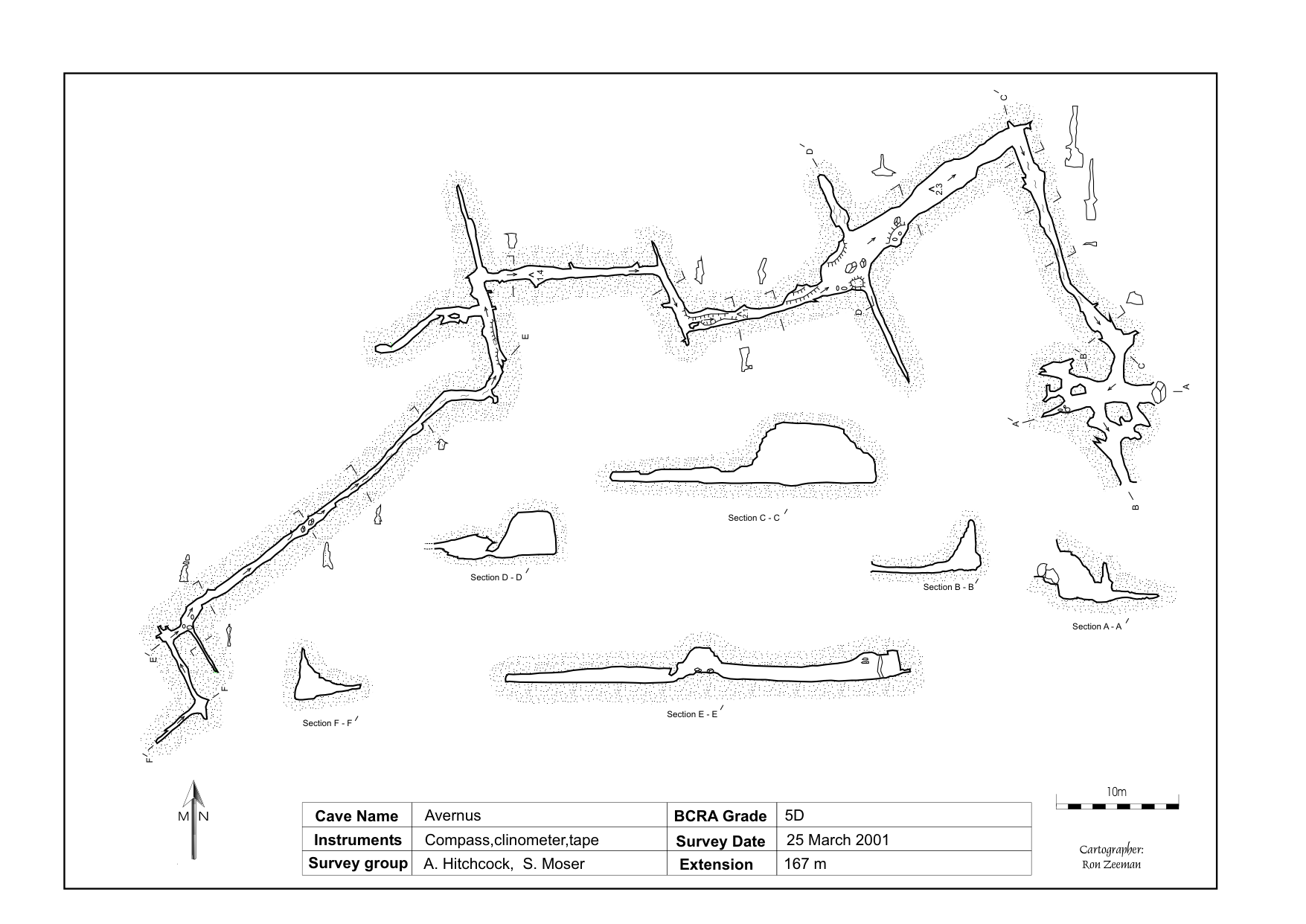
Extension: 167m
Introduction
The entrance to Avernus is on the cliff that overlooks the Fishhoek Valley. It was named by John Meyer after a crater lake in Italy, near Naples. In ancient times the lake was regarded as an entrance to hell. In his diaries, Meyer records painting the name on the 21st February 1924. Like White dome Grotto it must have been known before this date as it is less than 20m from Boomslang Cave.
Breakthrough, Exploration and Description
Up until the end of the 1970’s Avernus was known as a small uninteresting grotto about 20m long. Certainly it did not warrant its name at that time. The interest in exploration was rejuvenated after some discoveries in Oread Halls. The stream and accompanying loads of pure white silt emanating from the vertical crevice at the back of Avernus aroused new interest. Anthony Hitchcock and Dave Eckles set about probing the constriction in 1980. They managed to dig down into the floor where the passage was marginally wider, but could not press their shoulders past a bulge in the wall. Tedious chipping at full stretch eventually widened the passage enough to allow progress to the other side of the constriction. The crevice widened until it was large enough to stand in. The passage floor is horizontal and takes a 90 degree turn to the left yielding a lovely pristine passage and small chamber in untouched white or pale orange rock. The ‘chamber’ is merely a widening of the passage to about 5m and 2,5m high. A low side passage leads into black sticky mud on the right while on the left a 10m long narrow slot arches over a rise and pinches out 10m away. The notable feature in this area is the thin veneers of layered rock that fold slightly in places giving one the impression of being inside a solidified sand dune.
The passage continues for a short distance and then narrows forming a rocky channel in the floor that carries the small stream. The ceiling lowers and altogether the passage become smaller and more difficult to negotiate. After some sharp turns to the right and left the passage closes down 70m from the entrance. A tight wet channel leads right and then sharp left into a square shaped passage that continues for 30m disturbed only by a single collapse through which one must squeeze. The passage allows a brief respite as one can stand at this point, but soon splits and pinches into narrower avenues. A very narrow stream passage comes from the left. A constriction ahead opens to a small chamber beyond with a narrow slot to the left and a small amount of water flowing from the right. The left-hand passage presents a challenge to tight passage cavers. It is possible to slide through at stream level or to climb up and slip down into the passage beyond from above. The passage beyond presents a dark wet forbidding place with most thoughts centred on how to extricate oneself. After about 8m one ducks under the low ceiling and slides up a rocky slope into standing room. The passage heads to the right narrows to an impenetrable slot after 6m. The cave now presents an accumulated length of just over 150m compared to the original 20m before the breakthrough.
Survey
The survey coincided with the breakthrough and was less accurate as it was done only using a compass and not clinometer. The passages show the typical angular development of the quartzite caves on Kalk Bay Mountain. It shows that the cave has developed along joints that probably were initially weathered under water. The lowering of the water table and drainage to the surface probably undercut the jointed blocks causing collapse and widening in certain areas.
The survey was placed on the same map with Boomslang cave and proved to be most interesting. Passages in the two caves appear to come to within 5m of each other on the horizontal plane. The vertical difference could not be established, as we had not used a clinometer. Attempts to connect the two caves have not been successful and physical evidence in the caves doesn’t suggest that the two passages be connected.
The passage in Avernus has a vertical orientation while the one in Boomslang is low and flat. Water issues from the latter, but there is no water in the former. There is no evidence of a through draft. The original survey was rather rough and needed vertical data to improve accuracy. On the 25th of March 2001 Stephan Moser and Anthony Hitchcock resurveyed the cave as accurately as possible using Suunto compass, clinometer and tape.
Fauna
There are cave crickets and plenty of spiders in the entrance area. The stream supports lots of shrimps and the occasional bat has been encountered.
Safety
Avernus is a horizontal cave, but must not be underestimated by the explorer. There are a number of very tight sections namely the squeeze from the entrance grotto into the main system, a constricted slot two thirds into the cave, partially collapsed ceiling a little further, and the very tight section at the end. Added to this is the fact that one usually gets wet when first entering the cave. So the possibility of hypothermia if someone becomes stuck.
Extract from Fire Protection Services booklet
Avernus, 60 feet away, is a small dark cave and, although at first glance it looks formidable, it hardly justifies its name.